%20(2)-1.png?v=2)
Cal Fire is looking for public input on proposed changes.
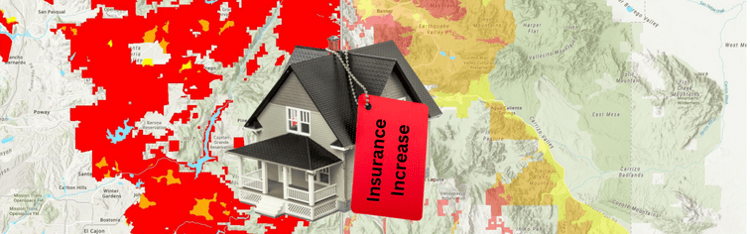
The California Department of Forestry and Fire Protection, typically called CAL Fire, is updating its wildfire risk maps for rural, unincorporated areas throughout the state. It’s been 15 years since the maps were updated.
The updates have the potential for increasing the cost of homeowners insurance in those rural communities reclassified by CAL Fire as more susceptible to wildfires. Metropolitan cities and urban areas are not included in the current updates process.
The public is invited to comment and ask questions about updates to CAL Fire’s Wildfire Hazard Severity Zones (WHSZ) maps. The deadline for public comment is Feb. 3, 2023.
PSAR members are invited to visit a website and enter a property’s address on a map showing CAL Fire’s updates to WHSZ maps. Visit https://osfm.fire.ca.gov/divisions/community-wildfire-preparedness-and-mitigation/wildfire-preparedness/fire-hazard-severity-zones/, then scroll to the bottom to find “FHSZ Viewer” and enter an address in the search bar.
You can also visit https://bit.ly/calfiremaps to compare proposed 2022 updates to WHSZ maps, compared to WHSZ maps used in 2007, the year when WHSZ maps were last updated. At this website, you can use a swipe tool to toggle between the maps from 2007 and 2022, and see how ratings for areas have been changed to moderate, high and very high risks.
A CAL Fire statement said fire scientists and wildfire mitigation experts have used science-based and field-tested models to assign a hazard score based on factors that influence fire likelihood and fire behavior. Factors include fire history, existing and potential fuel (natural vegetations), predicted flame length, blowing embers, terrain and typical fire weather for an area.
CAL Fire also said insurance companies, including insurance agents and brokers, have been involved throughout the process to ensure cooperation between all sectors to better support Californians.
These changes to wildfire ratings are expected to impact insurance rates, as well as eligibility. While California has a FAIR property insurance plan that provides basic insurance to individuals unable to get coverage, this coverage is considered a “temporary safety net” until the homeowner can obtain a traditional homeowners policy. Even then, homeowners may need to obtain additional insurance from another carrier to increase their coverage to an adequate level.
Written comments can be mailed to FHSZ Comments, California Dept. of Forestry and Fire Protection, P.O. Box 944246, Sacramento, CA 94244-2460.
Comments also can be emailed to Josh Black, San Diego’s contact for the WHSZ map updates program. Black can be reached at josh.black@fire.ca.gov or (619) 609-3413.
PSAR's Mission is to empower Real Estate Professionals.
Since 1928, the Pacific Southwest Association of REALTORS® has played a significant role in shaping the history, growth and development of the Real Estate industry in San Diego County.